Tour Overview
Lemosho Ascent & Horombo Descent by Mountain Bike
Embark on one of the most unique and challenging cycling expeditions in Africa—an adventurous 7-days mountain bike climb of Mount Kilimanjaro, ascending through the scenic Lemosho Route and descending through the legendary Horombo Route of Marangu. This double-route combination allows riders to experience both the western and eastern sides of the mountain, offering unmatched scenery, diverse landscapes, and thrilling riding terrain.
Your journey begins on the quiet forested trails of Lemosho, gradually rising through lush rainforest, heather & moorland, and the expansive Shira Plateau. As you climb higher into the alpine desert, the terrain becomes raw, technical, and incredibly rewarding. With strategic acclimatization and the support of experienced mountain bike guides, you push toward the summit of Uhuru Peak (5,895m)—the Roof of Africa.
After the summit celebration, the adventure turns into an adrenaline-filled descent as you drop dramatically from the crater rim down to Kibo Hut and all the way to Horombo Hut. The final ride through the Marangu forest offers long, flowing tracks—an unforgettable finish to this epic cycling expedition.
This extraordinary tour is designed for experienced and highly fit mountain bikers seeking an extreme, world-class challenge with professional support, full equipment, hot meals, and expert safety measures every step of the way.
Tour Highlights
Cycle around the base of Mount Kilimanjaro, Africa’s highest peak
Ride through lush coffee and banana plantations on the southern slopes
Experience Chagga and Maasai cultures through authentic local interactions
Traverse forest trails, open plains, and rural dirt roads
Spot wildlife such as giraffes, zebras, and antelopes in natural surroundings
Explore Rau Forest, Materuni Waterfalls, and Maasai steppe regions
Stay in charming lodges, camps, and cultural accommodations
Professional cycling guides and support vehicle included throughout
Unforgettable mountain and savannah views perfect for photography
Tour Itinerary
Day 1: Hotel to Mti Mkubwa Camp
After breakfast and briefing, drive to Lemosho Park Gate. From here a forest track requiring a 4WD vehicle leads to Lemosho Glades. Walk along forest trails to Mti Mkubwa (big tree) campsite.
Elevation: 1830m/6000ft to 2650m/8700ft
Distance: 6km/4mi
Hiking Time: 2-3 hours
Habitat: Montane Forest
Meals: Lunch and Dinner
Day 2: Mti Mkubwa Camp to Shira 2 Camp
After breakfast, we continue as the trail gradually steepens and enters the giant heather moorland zone. After several streams are crossed we continue over the Shira Ridge past the Shira 1 camp and on to the Shira 2 camp on moorland meadows by a stream.
Elevation: 2650m/8700ft to 3850m/12,600ft
Distance: 16km/10mi
Hiking Time: 7-8 hours
Habitat: Moorland
Meals: Breakfast, Lunch and Dinner
Day 3: Shira 2 Camp to Barranco Camp
From the Shira Plateau we continue to the east up a ridge, passing the junction towards the peak of Kibo. As we continue, our direction changes to the South East towards the Lava Tower, called the “Shark’s Tooth” (elev 4650m/15,250ft). Shortly after the tower we come to the second junction which goes to the Arrow Glacier. We now continue down to the Barranco Camp. Although you end the day around the same elevation as when you began, this day is very important for acclimatization and will help your body prepare for summit day.
Elevation: 3850m/12,600ft to 4000m/13,000ft
Distance: 8km/5mi
Walking Time: 5-6 hours
Habitat: Semi-desert
Meals: Breakfast, Lunch and Dinner
Day 4: Barranco Camp to Karanga Camp
After breakfast, we leave Barranco and continue on a steep ridge up the Barranco Wall to the Karanga Valley and the junction which connects with the Mweka Trail.
Elevation: 4000m/13,000ft to 4050m/13,250ft
Distance: 5km/3mi
Climbing Time: 3-4 hours
Habitat: Alpine Desert
Meals: Breakfast, Lunch and Dinner
Day 5: Karanga Camp to Barafu Camp
We continue up to the Barafu Camp. You have completed the South Circuit, which offers views of the summit from many different angles. Here we make camp, rest, enjoy dinner, and prepare for the summit day.
Elevation: 4050m/13,250ft to 4700m/15,350ft
Distance: 4km/2mi
Climbing Time: 3-4 hours
Habitat: Alpine Desert
Meals: Breakfast, Lunch and Dinner
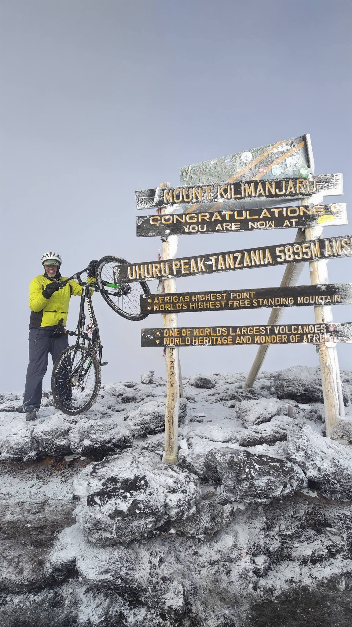
Day 6: Barafu Camp to Uhuru Peak ride down to Kibo the to Horombo
After a cup of tea and light snacks, the climb begins at around midnight. We continue our way to the summit between the Rebmann and Ratzel glaciers. You head in a northwesterly direction and ascend through heavy scree towards Stella Point on the crater rim. This is the most mentally and physically challenging portion of the trek.
At the stella point (18,600 ft), you will stop for a short rest and will be rewarded with the most magnifient sunrise you are ever likely to see (depending on the weather). At Uhuru Peak, you have reached the highest point on Mount Kilimanjaro and the continent of Africa. Faster hikers will see the sunrise from the summit.
Arriving at Uhuru Peak you will find your bike at the peak spends some few minutes and take photos, then ride down to Stella Point then Kibo hut for Lunch. After lunch ride down to Horombo Hut. Today cycling from Uhuru to Kibo 30% to 40% icecap vegetation and 15% to 20% is alpine desert and from Kibo to Horombo 100% Alphine vegetation.
Barafu Camp to Uhuru Peak
Uhuru Peak to Horombo Hut
Elevation 15,331 ft to 19,341 ft
Altitufe 5895 m 3700 m (Riding down)
Distance 5 km / 3 miles
Distance: 14 km down Altitude: 4640 m to 5895 m
Habitat: Arctic / Alpine desert
Hiking Time: 7-8 hours
Hiking Time: 4-6 hours
Habitat: Arctic
Meals: Breakfast, Lunch & Dinner
Day 7: Horombo Hut to Kilema Gate to Marangu then Drive Back to Moshi with Memories
After breakfast, make your final riding down to Kilema Gate across the alpine and the rainforest to Kilema gate then you will be transferred to Marangu Gate for check out.
A vehicle will meet you at Marangu gate to drive you back to your hotel in Moshi.
Altitude: 3700 m to 1700 m
Distance: 18 km down to Kilema Gate
Time: 3 hours
Meals: Breakfast & Lunch
KILIMANJARO DOUBLE ROUTE BIKE TREK FAQ
1. What is the difficulty level of this tour?
This is an advanced trek and bike expedition. You will climb from 2,100 m to 5,895 m (Uhuru Peak) over 7 days, alternating between cycling and pushing your bike. High-altitude acclimatization, endurance, and experience on rough terrain are essential.
2. How fit do I need to be?
Participants should have excellent cardiovascular fitness and prior biking experience, ideally with off-road or mountain biking. Training with long uphill rides and endurance sessions for 8–12 weeks before the tour is highly recommended.
3. Do I need previous high-altitude experience?
While previous high-altitude experience is beneficial, proper acclimatization built into the itinerary (Shira Plateau, Lava Tower, Barranco Wall) allows most healthy participants to complete the trek safely. Pre-existing medical conditions should be discussed with your doctor.
4. What kind of bike is used?
We provide sturdy mountain bikes suitable for off-road and rocky terrain. Bikes are checked daily. Riders are welcome to bring their own mountain bike if preferred.
5. What is the terrain like?
The terrain varies by day:
Forested single-track trails with roots and mud (Day 1–2)
High-altitude alpine desert, rocky plateaus, volcanic scree (Day 2–5)
Smooth descending trails through moorland and rainforest (Day 6)
Some sections require pushing or carrying the bike, especially steep rocks and the Barranco Wall.
6. How much riding vs. pushing is involved?
Depending on the day:
Day 1–2: Mostly pushing with short cycling sections
Day 3–5: Alternating push and ride; summit push almost entirely on foot
Day 6: Mostly downhill riding
7. What altitude will I reach?
Highest point: Uhuru Peak, 5,895 m
Base camp elevations: Mti Mkubwa 2,820 m, Shira 2 3,850 m, Barafu 4,673 m, Horombo 3,720 m
8. How are meals and accommodation arranged?
Camping at designated campsites with tents provided
Meals: Breakfast, lunch, dinner included; high-calorie, balanced meals suitable for altitude
9. What is included in the tour package?
Mountain bike rental and maintenance
Certified guides and porters
Camping gear (tent, sleeping mat)
Meals and water filtration during the trek
National park fees and summit fees
10. What gear should I bring?
Warm clothing for high-altitude (layers, gloves, hat)
Waterproof jacket and pants
Hiking boots suitable for cycling and hiking
Helmet and biking gloves
Personal water bottle and hydration system
Sunglasses and sunscreen
Personal medication
11. Is it safe to bike at high altitude?
Yes, but you must pace yourself. Pushing your bike is normal on steep or rocky sections. Guides monitor for altitude sickness. Hydration and rest are critical.
12. What happens if I cannot continue to the summit?
The guides can adjust your route. You can descend with support, ride easier sections, or wait at a lower camp. Safety is prioritized over summit completion.
13. Can I use my own bike?
Yes, but it must be a mountain bike in good condition suitable for off-road terrain. Suspension bikes are recommended. We also provide bikes if you prefer.
14. How do I prepare physically?
Long uphill bike rides and interval training
Hiking or trekking practice on uneven terrain
Cardiovascular endurance training
Strength training for legs, core, and back
15. What time of year is best for this tour?
Dry season: January–March and June–October
Avoid rainy months (April–May, November) for safety and trail conditions
16. Is this tour suitable for beginners?
No. This tour is for experienced cyclists and hikers with good fitness. Beginners may struggle with altitude, steep terrain, and endurance required.
17. What is the daily schedule like?
Early breakfast at camps
Climb/ride until lunch break
Afternoon push/ride to next camp
Evening: dinner, rest, prepare for next day
Summit night begins before midnight on Day 5
18. Are porters allowed to carry the bikes?
Yes, on difficult sections like the Barranco Wall or steep scree, porters assist with carrying bikes to ensure safety.
19. Will I need trekking poles?
Yes, trekking poles are highly recommended for balance while pushing the bike on steep terrain and scree sections.
20. What if I get altitude sickness?
Guides are trained to recognize symptoms. Rest, hydration, and gradual ascent are key. In severe cases, descent is immediate and evacuation arranged if needed.